


Rando Dudu du 12-08-2019

dudu85
User
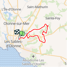

Length
22 km

Max alt
60 m

Uphill gradient
125 m
Km-Effort
24 km

Min alt
17 m

Downhill gradient
129 m
Boucle
No
Creation date :
2019-08-12 08:44:48.0
Updated on :
2019-08-12 13:40:17.551
4h10
Difficulty : Unknown

FREE GPS app for hiking
 SityTrail
IGN / Geographical institutes
SityTrail Plus
The world is yours!
About
Trail Walking of 22 km to be discovered at Pays de la Loire, Vendée, Les Sables-d'Olonne. This trail is proposed by dudu85.
Description
Départ et retour maison Olonne
Positioning
Country:
France
Region :
Pays de la Loire
Department/Province :
Vendée
Municipality :
Les Sables-d'Olonne
Location:
Olonne-sur-Mer
Start:(Dec)
Start:(UTM)
594893 ; 5151098 (30T) N.
Comments